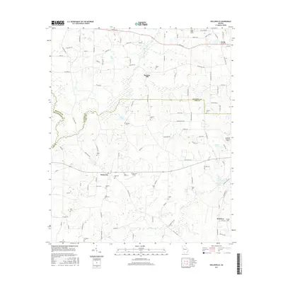
2017 Map of Hollonville
USGS Topo · Published 2017About this map
The Flint River carves a winding path through the borderlands of Pike, Spalding, and Meriwether counties, anchoring a rural landscape defined by small crossroads settlements and family burial grounds. In the late 2010s, Hollonville and Zetella serve as central points for a community connected by a network of farm-to-market roads like Newman Rd and Hollonville Rd. The presence of numerous small airfields, such as Alexander Memorial Airport, Cedar Ridge Airport, and Vintage Field, suggests a modern aviation character layered over the traditional agricultural roots of places like Blantons Mill. Genealogists will find significant value in the dense distribution of local cemeteries, including Hollonville Cem, Flat Rock Cem, and Friendship Cem, which mark the generational tenure of families in this corner of middle Georgia.
Find a feature on this map
102 named features on this map. Tap any name to fly to it.
Don’t see what you’re looking for? This feature index may not catch every label — zoom into the map to look around manually.
Map Details
Editions of this 2017 Hollonville Map
This is the sole edition of this map. No revisions or reprints were ever made.
Other maps of this area

1953 · Atlanta
USGS Topo · 1:250,000

1957 · Atlanta
USGS Topo · 1:250,000

1958 · Atlanta
USGS Topo · 1:250,000

1965 · Senoia
USGS Topo · 1:24,000

1965 · Griffin North
USGS Topo · 1:24,000

1965 · Brooks
USGS Topo · 1:24,000

1971 · Hollonville
USGS Topo · 1:24,000
1971 · Haralson
USGS Topo · 1:24,000
1971 · Gay
USGS Topo · 1:24,000
1971 · Griffin South
USGS Topo · 1:24,000