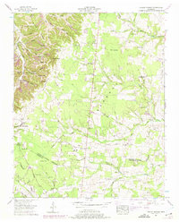
1953 Map of Hollow Springs
USGS Topo · Published 1975About this map
The Tennessee Valley Divide cuts through this landscape, separating the rugged hollows and ridges of the Highland Rim. In the early 1950s, this area of Tennessee was defined by small rural hubs such as Hollow Springs and McMahan, where life centered around local landmarks like Wildwood Mill and numerous country churches including Simmons Chapel and Amity Ch. The map reveals a dense network of family-named cemeteries such as Milligan Cem, King Cem, and Cherry Cem, which serve as vital markers for genealogical research in this region. Settled pockets like Pocahontas and Liberty are shown alongside essential community infrastructure of the era, including the Greedville Sch and Hopewell Sch. The terrain is deeply incised by water features like Jameson Hollow and Carson Fork, while upland features like Rains Ridge and Sinkhole Ridge underscore the geological complexity of the Cannon and Coffee County border.
Find a feature on this map
76 named features on this map. Tap any name to fly to it.
Don’t see what you’re looking for? This feature index may not catch every label — zoom into the map to look around manually.
Map Details
Editions of this 1953 Hollow Springs Map
2 editions found
Other maps of this area

1893 · Mc Minnville
USGS Topo · 1:125,000

1895 · Mc Minnville
USGS Topo · 1:125,000

1908 · Woodbury
USGS Topo · 1:62,500

1913 · Hollow Springs
USGS Topo · 1:62,500

1936 · Fredonia
USGS Topo · 1:24,000

1936 · Beech Grove
USGS Topo · 1:24,000

1936 · Petty Gap
USGS Topo · 1:24,000

1936 · Noah
USGS Topo · 1:24,000

1936 · Morrison
USGS Topo · 1:24,000

1942 · Statesville
USGS Topo · 1:100,000