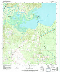
1994 Map of Holloway
USGS Topo · Published 1996About this map
The low-lying wetlands where the Little River meets the northern expanse of Catahoula Lake dominate this mid-1990s survey of the Rapides and La Salle Parish border. This landscape is a complex intersection of natural drainage and heavy industry, where the South Catahoula Oil Field and West Saline Lake Oil Field operate amidst protected marshlands. Extensive bayous like Big Bayou and Alligator Bayou weave through the Saline State Wildlife Management Area, illustrating the region's dual identity as both a resource extraction hub and a conservation zone. Near the small settlement of Holloway, the presence of a Gaging Station and a Pumping Station highlights the managed nature of these waterways. Local history is anchored by family-named landscape features such as Routh Point and Evans Br, alongside the quiet presence of a Cem and Schoolhouse Br, reflecting a dispersed rural community established along the higher ground of the lake's periphery.
Find a feature on this map
35 named features on this map. Tap any name to fly to it.
Don’t see what you’re looking for? This feature index may not catch every label — zoom into the map to look around manually.
Map Details
Editions of this 1994 Holloway Map
This is the sole edition of this map. No revisions or reprints were ever made.
Other maps of this area

1936 · Pollock
USGS Topo · 1:62,500

1941 · Jena
USGS Topo · 1:62,500

1941 · Alexandria
USGS Topo · 1:62,500

1941 · Buckeye
USGS Topo · 1:62,500

1941 · Pollock
USGS Topo · 1:62,500

1953 · Alexandria
USGS Topo · 1:250,000

1955 · Alexandria
USGS Topo · 1:250,000

1957 · Alexandria
USGS Topo · 1:62,500

1958 · Pollock
USGS Topo · 1:62,500

1958 · Jena
USGS Topo · 1:62,500