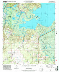
1998 Map of Holloway
USGS Topo · Published 2004About this map
The low-lying wetlands of Catahoula Lake dominate this portion of Central Louisiana, where the borders of Rapides, Grant, and La Salle Parishes converge. The landscape is defined by an intricate network of waterways including Little River, Saline Bayou, and Alligator Bayou, which flow through seasonal floodplains like Catfish Prairie and Middle Prairie. Industrial activity is evident in the South Catahoula Oil Field and another unnamed Oil Field near West Saline Lake, connected by various pipelines that cut across the swampy terrain. The small settlement of Holloway sits on higher ground to the southwest, serving as a rare point of habitation near the vast Dewey W Willis State Wildlife Management Area and the Camp Beauregard military training grounds.
Find a feature on this map
36 named features on this map. Tap any name to fly to it.
Don’t see what you’re looking for? This feature index may not catch every label — zoom into the map to look around manually.
Map Details
Editions of this 1998 Holloway Map
This is the sole edition of this map. No revisions or reprints were ever made.
Other maps of this area

1936 · Pollock
USGS Topo · 1:62,500

1941 · Jena
USGS Topo · 1:62,500

1941 · Alexandria
USGS Topo · 1:62,500

1941 · Buckeye
USGS Topo · 1:62,500

1941 · Pollock
USGS Topo · 1:62,500

1953 · Alexandria
USGS Topo · 1:250,000

1955 · Alexandria
USGS Topo · 1:250,000

1957 · Alexandria
USGS Topo · 1:62,500

1958 · Pollock
USGS Topo · 1:62,500

1958 · Jena
USGS Topo · 1:62,500