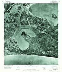
1975 Map of Holly Beach
USGS Topo · Published 1976About this map
Holly Beach sits at the southern edge of this orthophotograph, where the Louisiana coastline meets the Gulf of Mexico. Prepared from 1975 aerial photography, the map illustrates the delicate geography of Cameron Parish before later decades of significant coastal change. The landscape is defined by the expansive waters of Calcasieu Lake and the distinct horseshoe shape of Mud Lake, which dominates the central terrain. This view reveals the density of the marshlands and the narrow strip of human settlement along the shoreline, providing a clear record of the road patterns and structure footprints that characterized the community during the mid-1970s. The intricate network of small waterways and drainage patterns throughout the wetlands reflects the natural hydrology of the region at that time.
Find a feature on this map
4 named features on this map. Tap any name to fly to it.
Don’t see what you’re looking for? This feature index may not catch every label — zoom into the map to look around manually.
Map Details
Editions of this 1975 Holly Beach Map
This is the sole edition of this map. No revisions or reprints were ever made.
Other maps of this area

1934 · Cameron
USGS Topo · 1:24,000

1934 · Holly Beach
USGS Topo · 1:24,000

1934 · Peveto Beach
USGS Topo · 1:24,000

1934 · Browns Lake
USGS Topo · 1:24,000

1934 · Five Lakes
USGS Topo · 1:24,000

1935 · Peveto Beach
USGS Topo · 1:31,680

1935 · Cameron
USGS Topo · 1:31,680

1935 · Five Lakes
USGS Topo · 1:31,680

1935 · Hackberry
USGS Topo · 1:31,680

1935 · Holly Beach
USGS Topo · 1:31,680