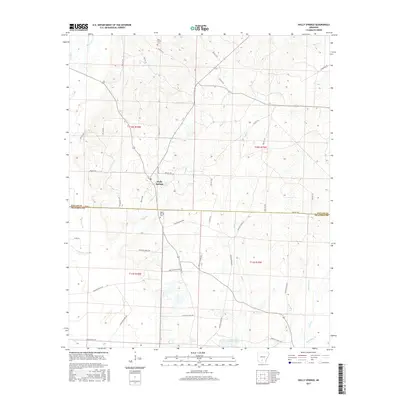
2017 Map of Holly Springs
USGS Topo · Published 2017About this map
Holly Springs serves as the central hub of this South Arkansas landscape, situated along the border of Dallas and Ouachita counties. The settlement is defined by its rural road network and proximity to essential community landmarks like the Holly Springs Cem and the Oak Grove Cem further north. The terrain is characterized by a dense network of watercourses, where drainage from Tulip Cr and White Oak Cr feeds into the larger regional basins. To the south, the landscape transitions toward Garner Lake Number One and Scale Springs, illustrating the wetland and spring-fed nature of the Arkansas timberlands. Numerous local routes, such as Ouachita Road 95 and Dallas 123, provide a detailed record of the rural infrastructure connecting disparate homesteads and timber tracts during the early 21st century.
Find a feature on this map
51 named features on this map. Tap any name to fly to it.
Don’t see what you’re looking for? This feature index may not catch every label — zoom into the map to look around manually.
Map Details
Editions of this 2017 Holly Springs Map
This is the sole edition of this map. No revisions or reprints were ever made.
Other maps of this area

1903 · Camden
USGS Topo · 1:125,000

1953 · El Dorado
USGS Topo · 1:250,000

1957 · El Dorado
USGS Topo · 1:250,000

1958 · El Dorado
USGS Topo · 1:250,000

1960 · El Dorado
USGS Topo · 1:250,000
1971 · Sparkman
USGS Topo · 1:24,000

1971 · Ouachita
USGS Topo · 1:24,000
1971 · Harmony Grove
USGS Topo · 1:24,000

1973 · Bearden
USGS Topo · 1:24,000
1973 · Eagle Mills
USGS Topo · 1:24,000