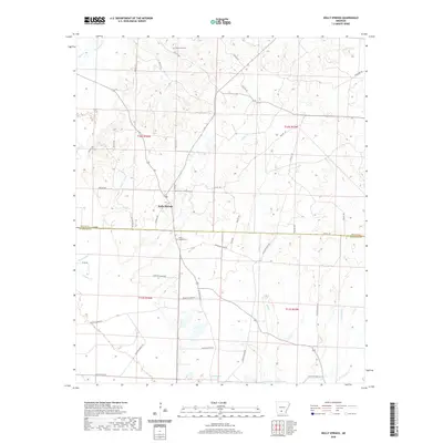
2020 Map of Holly Springs
USGS Topo · Published 2020About this map
Holly Springs serves as the central hub of this South Arkansas landscape, situated where the northern forest hills of Dallas County and Ouachita County meet. The area is defined by an intricate network of watercourses, including Tulip Creek, White Oak Creek, and the headwaters of Freeo Creek. Local history is anchored by the Holly Springs Cemetery and Oak Grove Cemetery, while the presence of Scale Springs and Garner Lake Number One points to the vital role of water resources in this timber-rich region. The map details a transition from the rolling terrain north of the county line into the lower creek bottoms to the south, where Steamboat Creek and Mill Creek converge.
Find a feature on this map
48 named features on this map. Tap any name to fly to it.
Don’t see what you’re looking for? This feature index may not catch every label — zoom into the map to look around manually.
Map Details
Editions of this 2020 Holly Springs Map
This is the sole edition of this map. No revisions or reprints were ever made.
Other maps of this area

1903 · Camden
USGS Topo · 1:125,000

1953 · El Dorado
USGS Topo · 1:250,000

1957 · El Dorado
USGS Topo · 1:250,000

1958 · El Dorado
USGS Topo · 1:250,000

1960 · El Dorado
USGS Topo · 1:250,000
1971 · Sparkman
USGS Topo · 1:24,000

1971 · Ouachita
USGS Topo · 1:24,000
1971 · Harmony Grove
USGS Topo · 1:24,000

1973 · Bearden
USGS Topo · 1:24,000
1973 · Eagle Mills
USGS Topo · 1:24,000