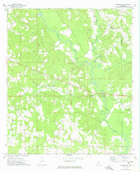
1972 Map of Holmesville
USGS Topo · Published 1974About this map
Bogue Chitto and Topisaw Creek converge in this corner of Southern Mississippi, shaping a landscape of river bottoms and gravel deposits. The historic settlement of Holmesville serves as a central landmark, supported by the Holmesville Cem and nearby community points like Beardens and Barto. The transition of regional infrastructure is evident in the path of the Illinois Central Gulf railroad and an older Old Railroad Grade that cuts across the western terrain near Stella.
Find a feature on this map
37 named features on this map. Tap any name to fly to it.
Don’t see what you’re looking for? This feature index may not catch every label — zoom into the map to look around manually.
Map Details
Editions of this 1972 Holmesville Map
This is the sole edition of this map. No revisions or reprints were ever made.
Other maps of this area

1953 · Natchez
USGS Topo · 1:250,000

1956 · Natchez
USGS Topo · 1:250,000

1959 · Natchez
USGS Topo · 1:250,000

1970 · Mesa
USGS Topo · 1:24,000

1970 · Jayess
USGS Topo · 1:24,000
1970 · Tylertown
USGS Topo · 1:24,000
1972 · Osyka
USGS Topo · 1:24,000

1972 · Pricedale
USGS Topo · 1:24,000

1972 · McComb South
USGS Topo · 1:24,000
1972 · McComb North
USGS Topo · 1:24,000