
1953 Map of Holopaw
USGS Topo · Published 1954About this map
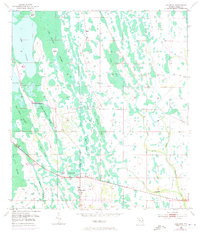
The settlement of Holopaw occupies a small clearing at the edge of a vast wetland system in Osceola County, captured here following a series of plane-table surveys in the early 1950s. The landscape is defined by its complex drainage network, where names like Cat Island Swamp, Jug Creek Swamp, and Big Bend Swamp reveal a terrain of seasonally shifting waters and low-lying hammocks. Elevated features like Cat Island and Storey Bend rise above the surrounding sloughs, providing critical dry ground for local activity.
Find a feature on this map
20 named features on this map. Tap any name to fly to it.
Don’t see what you’re looking for? This feature index may not catch every label — zoom into the map to look around manually.
Map Details
Editions of this 1953 Holopaw Map
2 editions found
Other maps of this area

1953 · Holopaw SE
USGS Topo · 1:24,000

1953 · Narcoossee SE
USGS Topo · 1:24,000

1953 · Narcoossee
USGS Topo · 1:24,000

1953 · Deer Park NW
USGS Topo · 1:24,000

1953 · Holopaw SW
USGS Topo · 1:24,000

1953 · Lake Poinsett SW
USGS Topo · 1:24,000

1953 · Deer Park
USGS Topo · 1:24,000

1953 · Ashton
USGS Topo · 1:24,000

1955 · Orlando
USGS Topo · 1:250,000

1957 · Orlando
USGS Topo · 1:250,000