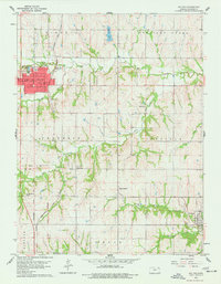
1960 Map of Holton
USGS Topo · Published 1977About this map
Holton serves as the focal point of this Jackson County landscape, characterized by its grid of urban streets and public spaces like Colorado Park and Linscott Park. The town’s economy and physical layout are tied to the Chicago Rock Island and Pacific railroad, which cuts through the region. Beyond the town limits, the terrain transitions into a patchwork of rural school districts and small agricultural hubs, including Birmingham and Denison.
Find a feature on this map
34 named features on this map. Tap any name to fly to it.
Don’t see what you’re looking for? This feature index may not catch every label — zoom into the map to look around manually.
Map Details
Editions of this 1960 Holton Map
3 editions found
Other maps of this area

1888 · Hiawatha
USGS Topo · 1:125,000

1889 · Topeka
USGS Topo · 1:125,000

1894 · Topeka
USGS Topo · 1:125,000

1894 · Hiawatha
USGS Topo · 1:125,000

1950 · Kansas City
USGS Topo · 1:250,000

1954 · Kansas City
USGS Topo · 1:250,000

1956 · Kansas City
USGS Topo · 1:250,000

1960 · Kansas City
USGS Topo · 1:250,000
1960 · Mayetta
USGS Topo · 1:24,000
1960 · Holton
USGS Topo · 1:24,000