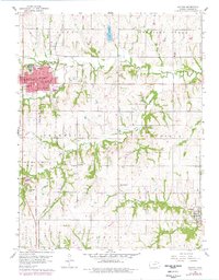
1960 Map of Holton
USGS Topo · Published 1978About this map
The county seat of Holton serves as the primary hub of this landscape, where the Chicago Rock Island and Pacific railroad cuts a diagonal path through the prairie terrain. The map captures a transition period in Jackson County, showing the town's expansion with additions like a trailer park and several local schools, including Central Sch and the High Sch. Significant historical markers delineate the countryside, such as the Old Indian Bdy Res and the Potawatomi Indian Boundary, which bisect the agricultural sections.
Find a feature on this map
31 named features on this map. Tap any name to fly to it.
Don’t see what you’re looking for? This feature index may not catch every label — zoom into the map to look around manually.
Map Details
Editions of this 1960 Holton Map
3 editions found
Other maps of this area

1888 · Hiawatha
USGS Topo · 1:125,000

1889 · Topeka
USGS Topo · 1:125,000

1894 · Topeka
USGS Topo · 1:125,000

1894 · Hiawatha
USGS Topo · 1:125,000

1950 · Kansas City
USGS Topo · 1:250,000

1954 · Kansas City
USGS Topo · 1:250,000

1956 · Kansas City
USGS Topo · 1:250,000

1960 · Kansas City
USGS Topo · 1:250,000
1960 · Mayetta
USGS Topo · 1:24,000
1960 · Holton
USGS Topo · 1:24,000