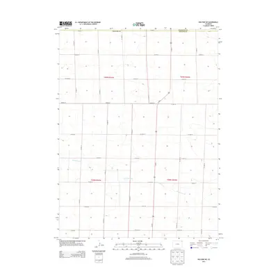
2013 Map of Holyoke NE
USGS Topo · Published 2013About this map
Wildhorse Creek meanders through the heart of this agricultural landscape in northeastern Colorado, marking one of the few natural breaks in the systematic grid of section roads. The map captures a high-plains region defined by the intersection of Phillips and Sedgwick counties, where the land is divided into precise townships including t009n r044w and t008n r045w. Transportation in this era is dominated by a dense network of local routes such as CO Road 38 and CO Road 35, which facilitate movement between rural homesteads and larger regional thoroughfares. The primary north-south artery, Us-385 N, bisects the area, serving as a vital link for the scattered agricultural operations. This survey provides a clear look at the modern rural infrastructure, showing how modern county road systems have preserved the traditional Public Land Survey System boundaries.
Find a feature on this map
23 named features on this map. Tap any name to fly to it.
Don’t see what you’re looking for? This feature index may not catch every label — zoom into the map to look around manually.
Map Details
Editions of this 2013 Holyoke NE Map
This is the sole edition of this map. No revisions or reprints were ever made.
Other maps of this area
1952 · Julesburg SW
USGS Topo · 1:24,000
1952 · Julesburg SE
USGS Topo · 1:24,000
1954 · Sterling
USGS Topo · 1:250,000
1958 · Sterling
USGS Topo · 1:250,000
1962 · Venango SW
USGS Topo · 1:24,000
1962 · Holyoke NE
USGS Topo · 1:24,000
1962 · Amherst
USGS Topo · 1:24,000
1962 · Holyoke NW
USGS Topo · 1:24,000
1971 · Paoli
USGS Topo · 1:24,000
1971 · Amherst SW
USGS Topo · 1:24,000