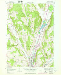
1978 Map of Homer
USGS Topo · Published 1979About this map
The Tioughnioga River valley serves as the primary corridor for development in this late 1970s view of Cortland County, where the village of Homer sits at the junction of the West Branch Tioughnioga River and Factory Brook. The landscape transitions from the dense residential grid and industrial footprints in Homer to the rural hamlets of Preble, Baltimore, and Slab City in the north. Extensive State Reforestation Areas blanket the higher elevations to the west, particularly around Scott, providing a sharp contrast to the active valley floor.
Find a feature on this map
52 named features on this map. Tap any name to fly to it.
Don’t see what you’re looking for? This feature index may not catch every label — zoom into the map to look around manually.
Map Details
Editions of this 1978 Homer Map
This is the sole edition of this map. No revisions or reprints were ever made.
Other maps of this area

1898 · Moravia
USGS Topo · 1:62,500

1899 · Skaneateles
USGS Topo · 1:62,500

1900 · Tully
USGS Topo · 1:62,500

1902 · Skaneateles
USGS Topo · 1:62,500

1902 · Moravia
USGS Topo · 1:62,500

1903 · Cortland
USGS Topo · 1:62,500

1942 · Groton
USGS Topo · 1:24,000

1943 · Spafford
USGS Topo · 1:31,680

1943 · Groton
USGS Topo · 1:31,680

1943 · Otisco Valley
USGS Topo · 1:31,680