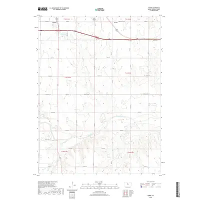
2018 Map of Homer
USGS Topo · Published 2018About this map
Russell and Homer anchor this Russell County landscape during the late 2010s, where the high plains meet the winding course of the Smoky Hill River. The river cuts an intricate path across the southern half of the quadrangle, fed by tributaries including Sellens Cr and Landon Cr. In the northwest, the city of Russell expands toward the Russell Municipal Airport, while Fossil Lake and Fossil Cr dominate the local drainage pattern south of the municipal center. The map documents a transition in transportation history, where the modern interstate corridor runs parallel to the older route of Old US Hwy 40. Rural sections are defined by a strictly organized grid of roads such as Pioneer Rd and Lincoln Rd, reflecting the enduring structure of the Public Land Survey System in central Kansas.
Find a feature on this map
41 named features on this map. Tap any name to fly to it.
Don’t see what you’re looking for? This feature index may not catch every label — zoom into the map to look around manually.
Map Details
Editions of this 2018 Homer Map
This is the sole edition of this map. No revisions or reprints were ever made.
Other maps of this area

1896 · Russell
USGS Topo · 1:125,000

1955 · Great Bend
USGS Topo · 1:250,000

1956 · Dorrance SW
USGS Topo · 1:24,000

1957 · Great Bend
USGS Topo · 1:250,000

1958 · Great Bend
USGS Topo · 1:250,000

1961 · Russell SW
USGS Topo · 1:24,000

1961 · Homer
USGS Topo · 1:24,000

1967 · Russell NW
USGS Topo · 1:24,000
1967 · Dorrance NW
USGS Topo · 1:24,000

1967 · Russell
USGS Topo · 1:24,000