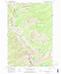
1966 Map of Homer Youngs Peak
USGS Topo · Published 1979About this map
Continental Divide defines the spine of this high-altitude landscape, marking the boundary between Montana and Idaho and the shared border of Salmon National Forest and Beaverhead National Forest. High-country mining history is preserved at the Ajax Mine below Ajax Peak and the Ore Cash Mine situated along the slopes near Monument Peak. This mid-1960s survey documents a network of primitive access routes, including various jeep trails and a pack trail system that connects remote alpine waters. Glacial features dominate the topography, with significant clusters like the Stay-a-melt Lakes, Rock Island Lakes, and Upper Miner Lakes feeding into drainages such as Big Swamp Creek and North Fork Kirtley Creek. The map provides specific elevations for major summits, most notably Homer Youngs Peak, which anchors the central terrain.
Find a feature on this map
39 named features on this map. Tap any name to fly to it.
Don’t see what you’re looking for? This feature index may not catch every label — zoom into the map to look around manually.
Map Details
Editions of this 1966 Homer Youngs Peak Map
4 editions found
Other maps of this area

1950 · Salmon
USGS Topo · 1:62,500

1951 · Salmon
USGS Topo · 1:62,500

1955 · Dillon
USGS Topo · 1:250,000

1956 · Goldstone Mtn
USGS Topo · 1:62,500

1957 · Dillon
USGS Topo · 1:250,000

1958 · Dillon
USGS Topo · 1:250,000

1962 · Dillon
USGS Topo · 1:250,000

1965 · Dillon
USGS Topo · 1:250,000

1966 · Badger Spring Gulch
USGS Topo · 1:24,000

1966 · Shewag Lake
USGS Topo · 1:24,000