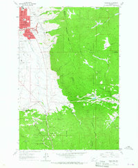
1963 Map of Homestake
USGS Topo · Published 1966About this map
The Continental Divide slices through the high timber of the Deerlodge National Forest, separating the urban expansion of Floral Park from the winding canyons to the east. This 1963 survey captures a transition in Montana transportation, showing Interstate 15 under construction or newly completed alongside older routes like the Chief Joseph Trail. The industrial legacy of the region is evident in the Tramway and numerous prospects that dot the slopes near Goldflint Mountain, while the rail corridor of the Northern Pacific and the Chicago Milwaukee ST Paul And Pacific remains a dominant feature of the landscape.
Find a feature on this map
50 named features on this map. Tap any name to fly to it.
Don’t see what you’re looking for? This feature index may not catch every label — zoom into the map to look around manually.
Map Details
Editions of this 1963 Homestake Map
2 editions found
Other maps of this area

1889 · Helena
USGS Topo · 1:250,000

1893 · Helena
USGS Topo · 1:250,000

1893 · Dillon
USGS Topo · 1:250,000

1899 · Boulder
USGS Topo · 1:125,000

1899 · Helena
USGS Topo · 1:250,000

1903 · Helena
USGS Topo · 1:250,000

1947 · Butte
USGS Topo · 1:250,000

1954 · Elk Park
USGS Topo · 1:62,500

1955 · Dillon
USGS Topo · 1:250,000

1957 · Dillon
USGS Topo · 1:250,000