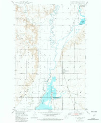
1948 Map of Homestead
USGS Topo · Published 1981About this map
Fort Peck Indian Reservation defines the western portion of this prairie landscape, where the boundary between Sheridan and Roosevelt counties bisects the southern reaches. The area is characterized by the meandering path of Big Muddy Creek and its complex of wetlands, including Homestead Lake and portions of the Medicine Lake Migratory Waterfowl Refuge. These water bodies are vital landmarks in an otherwise arid expanse of coulees and springs.
Find a feature on this map
17 named features on this map. Tap any name to fly to it.
Don’t see what you’re looking for? This feature index may not catch every label — zoom into the map to look around manually.
Map Details
Editions of this 1948 Homestead Map
2 editions found
Other maps of this area

1914 · Homestead
USGS Topo · 1:62,500

1947 · Rocky Point
USGS Topo · 1:24,000

1947 · Homestead
USGS Topo · 1:24,000

1948 · Homestead
USGS Topo · 1:24,000

1948 · Rocky Point
USGS Topo · 1:24,000

1948 · Medicine Lake
USGS Topo · 1:24,000

1948 · Reserve
USGS Topo · 1:24,000

1948 · Alkali Coulee
USGS Topo · 1:24,000

1949 · Reserve
USGS Topo · 1:24,000

1949 · Alkali Coulee
USGS Topo · 1:24,000