1992 Map of Homewood
USGS Topo · Published 1994About this map
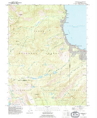
Lake Tahoe dominates the eastern edge of this high-altitude landscape, where shoreline communities like Homewood and Tahoe Pines serve as gateways to the surrounding wilderness. The terrain rises sharply from the water toward the peaks of the Tahoe National Forest and El Dorado National Forest. Evidence of recreational development is visible in the network of Ski Lifts above MC Kinney Bay and established sites like the Kaspian Campground.
Find a feature on this map
63 named features on this map. Tap any name to fly to it.
Don’t see what you’re looking for? This feature index may not catch every label — zoom into the map to look around manually.
Map Details
Editions of this 1992 Homewood Map
2 editions found

Other maps of this area

1889 · Pyramid Peak
USGS Topo · 1:125,000

1891 · Truckee
USGS Topo · 1:125,000

1891 · Pyramid Peak
USGS Topo · 1:125,000

1893 · Truckee
USGS Topo · 1:125,000

1895 · Pyramid Peak
USGS Topo · 1:125,000

1895 · Truckee
USGS Topo · 1:125,000

1896 · Pyramid Peak
USGS Topo · 1:125,000

1932 · Truckee
USGS Topo · 1:96,000

1940 · Truckee
USGS Topo · 1:125,000

1947 · Sacramento
USGS Topo · 1:250,000