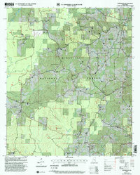
2000 Map of Homewood
USGS Topo · Published 2002About this map
Bienville National Forest encompasses much of this landscape, where the rural communities of Homewood and Burns serve as central points in the eastern half of Smith County. This topographic record, based on 1966 topography and 1996 imagery, reveals a territory defined by timber and extractive industry, most notably the Bentonite Pits and various pits situated near the Bentonite Branch and Lemon Branch. The map is particularly valuable for genealogical research, documenting numerous family-named and community landmarks such as Lingle Cemetery, Black Cemetery, and Roberts Cemetery. The dense network of country churches, including Gasque Chapel and Luther Chapel, reflects the established social fabric of these forest-bordering settlements. Drainage patterns are dominated by the Oakohay Creek and Caney Creek systems, which traverse the wooded terrain between small crossroads like Trenton and Lorena.
Find a feature on this map
49 named features on this map. Tap any name to fly to it.
Don’t see what you’re looking for? This feature index may not catch every label — zoom into the map to look around manually.
Map Details
Editions of this 2000 Homewood Map
This is the sole edition of this map. No revisions or reprints were ever made.
Other maps of this area

1921 · Forest
USGS Topo · 1:48,000

1922 · Forest
USGS Topo · 1:62,500

1922 · Morton
USGS Topo · 1:48,000

1924 · Morton
USGS Topo · 1:62,500

1935 · White Oak
USGS Topo · 1:24,000

1950 · Forest
USGS Topo · 1:62,500

1951 · Morton
USGS Topo · 1:62,500

1952 · Forest
USGS Topo · 1:62,500

1953 · Meridian
USGS Topo · 1:250,000

1957 · Meridian
USGS Topo · 1:250,000