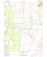
1952 Map of Honcut
USGS Topo · Published 1974About this map
Agricultural lands and riparian corridors define the landscape along the border of Butte and Yuba counties in the mid-20th century. The settlement of Honcut serves as a central hub where the Southern Pacific and Western Pacific railroads run parallel through the valley. To the south, the extensive La Finca Orchards and the Pacific Ranch highlight the region's long-standing reliance on irrigation and orchard farming.
Find a feature on this map
35 named features on this map. Tap any name to fly to it.
Don’t see what you’re looking for? This feature index may not catch every label — zoom into the map to look around manually.
Map Details
Editions of this 1952 Honcut Map
3 editions found
Other maps of this area

1888 · Marysville
USGS Topo · 1:125,000

1888 · Smartsville
USGS Topo · 1:125,000

1891 · Marysville
USGS Topo · 1:125,000

1891 · Smartsville
USGS Topo · 1:125,000

1892 · Smartsville
USGS Topo · 1:125,000

1894 · Smartsville
USGS Topo · 1:125,000

1894 · Marysville
USGS Topo · 1:125,000

1895 · Marysville
USGS Topo · 1:125,000

1895 · Smartsville
USGS Topo · 1:125,000

1911 · Sutter
USGS Topo · 1:31,680