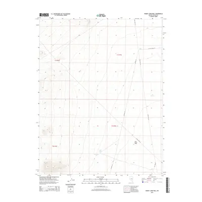
2015 Map of Honest John Well
USGS Topo · Published 2015About this map
Honest John Well anchors this remote section of Lincoln County, highlighting the critical importance of water sources in the arid high-desert interior. The landscape transitions into the broad expanse of the Sand Spring Valley, where seasonal moisture and spring-fed sites like Honest John Spring and Smith Spring dictated the early paths of travel and ranching. The presence of Able Reservoir further demonstrates the managed attempts to capture water in this environment.
Find a feature on this map
16 named features on this map. Tap any name to fly to it.
Don’t see what you’re looking for? This feature index may not catch every label — zoom into the map to look around manually.
Map Details
Editions of this 2015 Honest John Well Map
This is the sole edition of this map. No revisions or reprints were ever made.
Other maps of this area

1942 · Penoyer Valley
USGS Topo · 1:125,000

1952 · White Blotch Springs
USGS Topo · 1:62,500

1954 · Caliente
USGS Topo · 1:250,000

1959 · Caliente
USGS Topo · 1:250,000

1964 · Tempiute Mtn
USGS Topo · 1:62,500

1985 · McCutchen Spring
USGS Topo · 1:24,000
1985 · Black Top
USGS Topo · 1:24,000
1985 · Quinn Canyon Springs
USGS Topo · 1:24,000

1985 · Worthington Peak SW
USGS Topo · 1:24,000
1985 · Quinn Canyon Springs NW
USGS Topo · 1:24,000