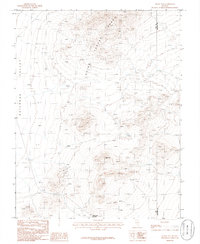
1985 Map of Black Top
USGS Topo · Published 1986About this map
The high-desert terrain of the Quinn Canyon Range dominates this mid-1980s provisional survey of the Nevada interior. At the center of the landscape stands the prominent peak of Black Top, a landmark for anyone navigating the transition between the basin and the mountain peaks. To the west, the flat expanse of Railroad Valley provides a stark contrast to the elevation, suggesting the isolation and scale of this corner of Nye County.
Find a feature on this map
7 named features on this map. Tap any name to fly to it.
Don’t see what you’re looking for? This feature index may not catch every label — zoom into the map to look around manually.
Map Details
Editions of this 1985 Black Top Map
This is the sole edition of this map. No revisions or reprints were ever made.
Other maps of this area

1908 · Kawich
USGS Topo · 1:250,000

1942 · Reveille Peak
USGS Topo · 1:125,000

1942 · Penoyer Valley
USGS Topo · 1:125,000

1952 · White Blotch Springs
USGS Topo · 1:62,500

1952 · Reveille Peak
USGS Topo · 1:62,500

1952 · Belted Peak
USGS Topo · 1:62,500

1954 · Caliente
USGS Topo · 1:250,000

1954 · Goldfield
USGS Topo · 1:250,000

1955 · Goldfield
USGS Topo · 1:250,000

1958 · Goldfield
USGS Topo · 1:250,000