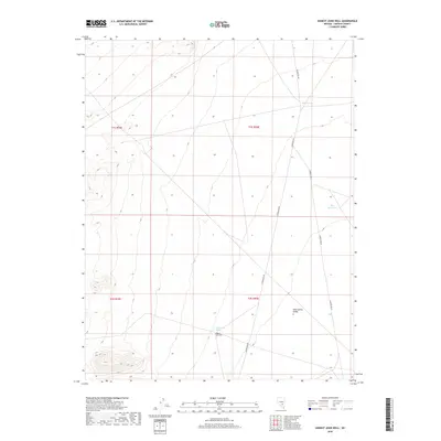
2018 Map of Honest John Well
USGS Topo · Published 2018About this map
Honest John Well anchors this high-desert landscape in Lincoln County, serving as a critical water source in the arid expanse of Sand Spring Valley. This 2018 survey illustrates a region defined by its sparse water infrastructure, where isolated points like Honest John Spring and Smith Spring dictate the movement of both people and livestock across the basin. The eastern edge of the quadrangle is marked by Shadow Wells and Able Reservoir, highlighting the essential role of water management in this high-elevation environment. Access to these remote reaches is maintained via Gunderson Rd, which traverses the valley floor against a backdrop of desert peaks and alluvial fans. The map provides a clear look at the Public Land Survey System (PLSS) grid, documenting the township and range boundaries that have organized this part of Nevada for generations.
Find a feature on this map
11 named features on this map. Tap any name to fly to it.
Don’t see what you’re looking for? This feature index may not catch every label — zoom into the map to look around manually.
Map Details
Editions of this 2018 Honest John Well Map
This is the sole edition of this map. No revisions or reprints were ever made.
Other maps of this area

1942 · Penoyer Valley
USGS Topo · 1:125,000

1952 · White Blotch Springs
USGS Topo · 1:62,500

1954 · Caliente
USGS Topo · 1:250,000

1959 · Caliente
USGS Topo · 1:250,000

1964 · Tempiute Mtn
USGS Topo · 1:62,500

1985 · McCutchen Spring
USGS Topo · 1:24,000
1985 · Black Top
USGS Topo · 1:24,000
1985 · Quinn Canyon Springs
USGS Topo · 1:24,000

1985 · Worthington Peak SW
USGS Topo · 1:24,000
1985 · Quinn Canyon Springs NW
USGS Topo · 1:24,000