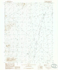
1986 Map of Honest John Well
USGS Topo · Published 1986About this map
Honest John Well serves as a critical water source in this arid high-desert landscape of Lincoln County, situated on the western edge of Spring Valley. This 1986 provisional edition captures the vast, open character of the Great Basin, where human presence is marked only by sparse infrastructure. A lone Corral and a primitive Trail are the primary indicators of ranching activity in an otherwise isolated basin floor. The terrain is defined by a rhythmic sequence of alluvial fans descending from the surrounding mountains, documented through detailed elevation points such as 5381at and 5107at. This survey reflects the mid-1980s era of land management, emphasizing the vital importance of localized water points for livestock and transit in the remote Nevada interior.
Find a feature on this map
61 named features on this map. Tap any name to fly to it.
Don’t see what you’re looking for? This feature index may not catch every label — zoom into the map to look around manually.
Map Details
Editions of this 1986 Honest John Well Map
This is the sole edition of this map. No revisions or reprints were ever made.
Other maps of this area

1942 · Penoyer Valley
USGS Topo · 1:125,000

1952 · White Blotch Springs
USGS Topo · 1:62,500

1954 · Caliente
USGS Topo · 1:250,000

1959 · Caliente
USGS Topo · 1:250,000

1964 · Tempiute Mtn
USGS Topo · 1:62,500

1985 · McCutchen Spring
USGS Topo · 1:24,000
1985 · Black Top
USGS Topo · 1:24,000
1985 · Quinn Canyon Springs
USGS Topo · 1:24,000

1985 · Worthington Peak SW
USGS Topo · 1:24,000
1985 · Quinn Canyon Springs NW
USGS Topo · 1:24,000