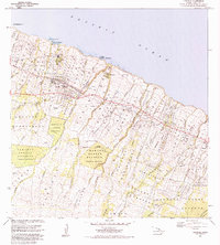
1983 Map of Honokaa
USGS Topo · Published 1984About this map
The Honokaa coastline along the Pacific Ocean is defined by a dense network of gulches and steep topographic rises moving inland toward the Hamakua Forest Reserve. The early 1980s landscape shows the transition from the coastal sugar mill settlements like Haina and Paauhau to the agricultural interior. The map documents significant land divisions including the Paauhau Homesteads and Kukuihaele Homesteads, which reflect the historic settlement patterns of the Hamakua Coast. Cultural landmarks such as the Honokaa Hospital, Rodeo Arena, and several community parks serve the primary town centers. This era shows the established infrastructure of the Mamalahoa Highway bypass, while numerous quarries and several plantation-era camps remain visible along the gulch-lined terrain between Paauilo and the northern cliffs.
Find a feature on this map
62 named features on this map. Tap any name to fly to it.
Don’t see what you’re looking for? This feature index may not catch every label — zoom into the map to look around manually.
Map Details
Editions of this 1983 Honokaa Map
2 editions found
Other maps of this area

1915 · Hamakua
USGS Topo · 1:62,500

1916 · Waipio
USGS Topo · 1:62,500

1954 · Hawaii North
USGS Topo · 1:250,000

1956 · Keanakolu
USGS Topo · 1:24,000

1956 · Makahalau
USGS Topo · 1:24,000

1956 · Umikoa
USGS Topo · 1:24,000

1957 · Kukaiau
USGS Topo · 1:24,000

1957 · Honokaa
USGS Topo · 1:24,000

1959 · Hawaii North
USGS Topo · 1:250,000

1961 · Hawaii North
USGS Topo · 1:250,000