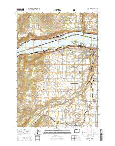
2014 Map of Hood River
USGS Topo · Published 2014About this map
The Columbia River serves as the central artery for this region, dividing the communities of Hood River, Oregon, and Underwood, Washington. This modern survey reflects a landscape shaped by both intense agriculture in the Hood River Valley and the legacy of early twentieth-century infrastructure, such as the series of rail passages including Tunnel No. 1 and Tunnel No. 4 along the northern shore. The southern banks reveal a dense network of fruit orchards and residential expansion around Rockford and Odell.
Find a feature on this map
108 named features on this map. Tap any name to fly to it.
Don’t see what you’re looking for? This feature index may not catch every label — zoom into the map to look around manually.
Map Details
Editions of this 2014 Hood River Map
This is the sole edition of this map. No revisions or reprints were ever made.
Other maps of this area

1926 · Hood River
USGS Topo · 1:125,000

1929 · Hood River
USGS Topo · 1:125,000

1934 · The Dalles
USGS Topo · 1:125,000

1953 · The Dalles
USGS Topo · 1:250,000

1956 · The Dalles
USGS Topo · 1:250,000

1957 · The Dalles
USGS Topo · 1:250,000

1957 · Willard
USGS Topo · 1:62,500

1957 · White Salmon
USGS Topo · 1:62,500

1957 · Husum
USGS Topo · 1:62,500

1957 · Hood River
USGS Topo · 1:62,500