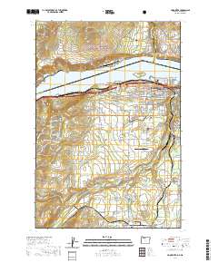
2020 Map of Hood River
USGS Topo · Published 2020About this map
The Hood River valley serves as a critical junction where the White Salmon River meets the Lake Bonneville pool of the Columbia River. This modern survey illustrates the dense agricultural and residential development south of the city, transitioning from the orchards of Odell and Pine Grove to the forested slopes of the Mount Hood National Forest. Local history is preserved in numerous burial sites such as Idlewilde Cem and Saint Mary's Cem, while the county seat is anchored by the Hood River County Court House. Transportation and industry remain central to the area's character, evidenced by the BNSF Railway corridor along the river and the Ken Jernstedt Airfield. To the north, across the state line, the settlements of White Salmon and Underwood overlook the water from the heights of the Gifford Pinchot National Forest, near the Spring Creek National Fish Hatchery.
Find a feature on this map
115 named features on this map. Tap any name to fly to it.
Don’t see what you’re looking for? This feature index may not catch every label — zoom into the map to look around manually.
Map Details
Editions of this 2020 Hood River Map
This is the sole edition of this map. No revisions or reprints were ever made.
Other maps of this area

1926 · Hood River
USGS Topo · 1:125,000

1929 · Hood River
USGS Topo · 1:125,000

1934 · The Dalles
USGS Topo · 1:125,000

1953 · The Dalles
USGS Topo · 1:250,000

1956 · The Dalles
USGS Topo · 1:250,000

1957 · The Dalles
USGS Topo · 1:250,000

1957 · Willard
USGS Topo · 1:62,500

1957 · White Salmon
USGS Topo · 1:62,500

1957 · Husum
USGS Topo · 1:62,500

1957 · Hood River
USGS Topo · 1:62,500