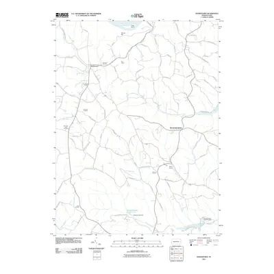
2010 Map of Hookstown
USGS Topo · Published 2010About this map
Hookstown and the surrounding Beaver County countryside are defined by a network of winding roads and numerous family and community landmarks in this 2010 survey. The landscape is dotted with several notable burial grounds, including Hookstown Cemetery, Mill Creek Cemetery, and Hanover Cemetery, which serve as vital points of reference for local genealogy. To the south, the extensive Raccoon Creek State Park occupies a significant portion of the terrain, featuring the Traverse Creek Dam and Main Lake. Along the northern edge, the Ohio River flows past Phillis Island and the Mallory Bar, highlighting the river's enduring role in the region's geography. Smaller hubs like Mechanicsburg and the Hookstown Grange anchor the rural community, while small aviation facilities like Fino Airport and McCoy Airport reflect the modern infrastructure that connects these more secluded areas to the wider region.
Find a feature on this map
75 named features on this map. Tap any name to fly to it.
Don’t see what you’re looking for? This feature index may not catch every label — zoom into the map to look around manually.
Map Details
Editions of this 2010 Hookstown Map
This is the sole edition of this map. No revisions or reprints were ever made.
Other maps of this area

1901 · Beaver
USGS Topo · 1:62,500

1904 · Wellsville
USGS Topo · 1:62,500

1904 · Steubenville
USGS Topo · 1:62,500

1904 · Beaver
USGS Topo · 1:62,500

1904 · Burgettstown
USGS Topo · 1:62,500

1906 · Burgettstown
USGS Topo · 1:62,500

1935 · Steubenville
USGS Topo · 1:62,500

1937 · Wellsville
USGS Topo · 1:62,500

1942 · Steubenville
USGS Topo · 1:62,500

1944 · Wellsville
USGS Topo · 1:62,500
Featured Places
- Hookstown, PA
- Greene Township, PA
- Raccoon Township, PA
- Hanover Township, PA
- Harshaville, Hanover Township