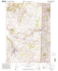
1995 Map of Hoosick Falls
USGS Topo · Published 2000About this map
Hoosick Falls and its surrounding river valleys define this landscape in the mid-1990s, where the convergence of the Hoosick River and the Walloomsac River has long shaped the local industrial and transport geography. The village itself is dense with detail, showing the grounds of the Hoosick Falls Country Club and the Maple Grove Cem south of the main settlement. Moving north, the map documents a transition from the industrial core to agricultural and memorial sites like the Bennington Battlefield Park, located near the Vermont border. This borderland character is central to the area's identity, with the state line cutting through timbered slopes of the Green Mountain National Forest. Cultural landmarks like the Drive-in Theater near North Hoosick and several surviving one-room schoolhouses, such as School No 16, provide specific points of interest for local historians and genealogists.
Find a feature on this map
40 named features on this map. Tap any name to fly to it.
Don’t see what you’re looking for? This feature index may not catch every label — zoom into the map to look around manually.
Map Details
Editions of this 1995 Hoosick Falls Map
This is the sole edition of this map. No revisions or reprints were ever made.
Other maps of this area

1894 · Equinox
USGS Topo · 1:62,500

1895 · Cambridge
USGS Topo · 1:62,500

1896 · Equinox
USGS Topo · 1:62,500

1897 · Hoosick
USGS Topo · 1:62,500

1898 · Cambridge
USGS Topo · 1:62,500

1898 · Bennington
USGS Topo · 1:62,500

1900 · Taconic
USGS Topo · 1:125,000

1900 · Equinox
USGS Topo · 1:62,500

1901 · Cambridge
USGS Topo · 1:62,500

1903 · Mettawee
USGS Topo · 1:125,000