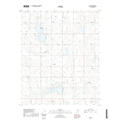
2018 Map of Hope
USGS Topo · Published 2018About this map
Duncan and the smaller settlements of Bray and Hope anchor this portion of Stephens County, where the landscape is defined by its water resources and rural aviation. The area is dominated by significant reservoirs including Clear Creek Lake and Duncan Lake, which serve as focal points for the surrounding sections. This 2018 survey illustrates a transition from the structured street grids of Duncan along Anderson St to the sprawling section roads of the surrounding townships. Genealogical value is found in the scattered rural burial grounds like Hope Cem, Colbert Cem, and Cruce Cem, which mark long-established communities. The presence of Ketchum Ranch Airport and Wolfe Field highlights the importance of light aviation in this region, while the network of creeks, such as Wildhorse Cr and Bluff Cr, drains the prairie terrain toward the reservoirs.
Find a feature on this map
44 named features on this map. Tap any name to fly to it.
Don’t see what you’re looking for? This feature index may not catch every label — zoom into the map to look around manually.
Map Details
Editions of this 2018 Hope Map
This is the sole edition of this map. No revisions or reprints were ever made.
Other maps of this area

1901 · Addington
USGS Topo · 1:125,000

1902 · Rush Springs
USGS Topo · 1:125,000

1950 · Marlow
USGS Topo · 1:62,500

1951 · Marlow
USGS Topo · 1:62,500

1957 · Ardmore
USGS Topo · 1:250,000

1963 · Ardmore
USGS Topo · 1:250,000

1963 · Harrisburg
USGS Topo · 1:24,000

1964 · Duncan South
USGS Topo · 1:24,000
1974 · Cox City
USGS Topo · 1:24,000
1974 · Velma
USGS Topo · 1:24,000