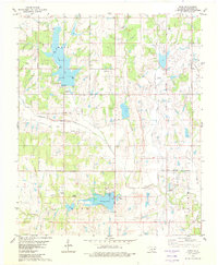
1982 Map of Hope
USGS Topo · Published 1982About this map
Bray and the small settlement of Hope anchor this rural Stephens County landscape in the early 1980s, an area defined by its water management and petroleum industry. The terrain is marked by significant reservoirs including Wall Lake, Clear Creek Lake, and Duncan Lake, which feature recreational infrastructure like the Camp Waluhiyi and several picnic areas. Local industry and utility are evidenced by the expansive Oil Field dotted with numerous Oil Wells, as well as specialized structures like a Fish Hatchery, a Pumping Station, and an Aqueduct located south of Clear Creek. Genealogy researchers will find value in the clearly marked Cooper Cem and Hope Cem, while the inclusion of the Ketchum Landing Strip and various boat ramps highlights the transportation and leisure patterns of this Oklahoma community.
Find a feature on this map
27 named features on this map. Tap any name to fly to it.
Don’t see what you’re looking for? This feature index may not catch every label — zoom into the map to look around manually.
Map Details
Editions of this 1982 Hope Map
This is the sole edition of this map. No revisions or reprints were ever made.
Other maps of this area

1901 · Addington
USGS Topo · 1:125,000

1902 · Rush Springs
USGS Topo · 1:125,000

1950 · Marlow
USGS Topo · 1:62,500

1951 · Marlow
USGS Topo · 1:62,500

1957 · Ardmore
USGS Topo · 1:250,000

1963 · Ardmore
USGS Topo · 1:250,000

1963 · Harrisburg
USGS Topo · 1:24,000

1964 · Duncan South
USGS Topo · 1:24,000
1974 · Cox City
USGS Topo · 1:24,000
1974 · Velma
USGS Topo · 1:24,000