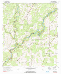
1971 Map of Hopeful
USGS Topo · Published 1991About this map
The winding Flint River defines the border between Baker and Mitchell counties in this 1971 survey of Southwest Georgia. The landscape is marked by the distinct hydraulic geometry of Horseshoe Bend and the convergence of several waterways, including Ichawaynochaway Creek and Cypress Creek. Settlement in this rural agricultural region is anchored by the community of Hopeful, where the Hopeful Lookout Tower stands as a prominent landmark. A network of country roads connects various small congregations that served as local social hubs, such as Pilgrim Home Ch, John the Baptist Ch, Thankful Ch, and Green Grove Ch. The presence of multiple landing strips suggests the importance of aerial crop dusting or private aviation to the local farming economy during the late twentieth century.
Find a feature on this map
13 named features on this map. Tap any name to fly to it.
Don’t see what you’re looking for? This feature index may not catch every label — zoom into the map to look around manually.
Map Details
Editions of this 1971 Hopeful Map
2 editions found
Other maps of this area

1953 · Dothan
USGS Topo · 1:250,000

1954 · Dothan
USGS Topo · 1:250,000

1955 · Dothan
USGS Topo · 1:250,000

1956 · Newton
USGS Topo · 1:62,500

1971 · Gee Pond
USGS Topo · 1:24,000

1971 · Vada
USGS Topo · 1:24,000

1971 · Hopeful
USGS Topo · 1:24,000
1971 · Branchville
USGS Topo · 1:24,000

1974 · Cooktown
USGS Topo · 1:24,000

1974 · Elmodel
USGS Topo · 1:24,000