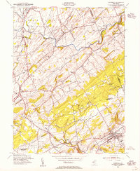
1954 Map of Hopewell
USGS Topo · Published 1955About this map
Hopewell serves as the focal point of this mid-century survey, situated at the crossroads of the Reading Railroad and various historic thoroughfares. The landscape transitions from the dense street grids of the town to the rural stretches of East Amwell and Hopewell townships. The map documents a high density of named corners and small settlements, such as Ringoes, Wertsville, and Larisons Corners, which reflect the region's agricultural heritage and local road-stop history.
Find a feature on this map
52 named features on this map. Tap any name to fly to it.
Don’t see what you’re looking for? This feature index may not catch every label — zoom into the map to look around manually.
Map Details
Editions of this 1954 Hopewell Map
4 editions found
Other maps of this area

1888 · Princeton
USGS Topo · 1:62,500

1890 · High Bridge
USGS Topo · 1:62,500

1890 · Lambertville
USGS Topo · 1:62,500

1891 · Somerville
USGS Topo · 1:62,500

1891 · Lambertville
USGS Topo · 1:62,500

1893 · Somerville
USGS Topo · 1:62,500

1894 · Princeton
USGS Topo · 1:62,500

1894 · Lambertville
USGS Topo · 1:62,500

1898 · High Bridge
USGS Topo · 1:62,500

1898 · Somerville
USGS Topo · 1:62,500
Featured Places
- Hillsborough Township, NJ
- Raritan Township, NJ
- Montgomery Township, NJ
- Hopewell Township, NJ
- Flemington, NJ