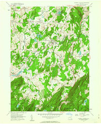
1957 Map of Hopewell Junction
USGS Topo · Published 1963About this map
Hopewell Junction sits at a critical rail intersection in southern Dutchess County, where the New York New Haven and Hartford railroad cuts across the mid-century landscape. This 1957 survey captures a period of transition as the New York State Thruway and Taconic State Parkway began to reshape the Hudson Valley, yet much of the area retains its traditional character. Local settlements like Fishkill Plains, Brinckerhoff, and Wiccopee are clearly defined alongside family landmarks such as the Van Wyck Cem and Van Dyne Cem. To the southeast, the terrain rises into the highlands where Shenandoah Mountain and Hosner Mountain dominate the horizon, crossed by the winding path of the Appalachian Trail. Smaller communities like Shenandoah and Lomala are shown near local water bodies including Gayhead Pond and Lake Walton, illustrating the balance between burgeoning infrastructure and the region's natural geography.
Find a feature on this map
41 named features on this map. Tap any name to fly to it.
Don’t see what you’re looking for? This feature index may not catch every label — zoom into the map to look around manually.
Map Details
Editions of this 1957 Hopewell Junction Map
3 editions found
Other maps of this area

1892 · West Point
USGS Topo · 1:62,500

1892 · Carmel
USGS Topo · 1:62,500

1893 · Carmel
USGS Topo · 1:62,500

1893 · Clove
USGS Topo · 1:62,500

1893 · Poughkeepsie
USGS Topo · 1:62,500

1894 · West Point
USGS Topo · 1:62,500

1894 · Clove
USGS Topo · 1:62,500

1894 · Carmel
USGS Topo · 1:62,500

1894 · Poughkeepsie
USGS Topo · 1:62,500

1898 · Clove
USGS Topo · 1:62,500