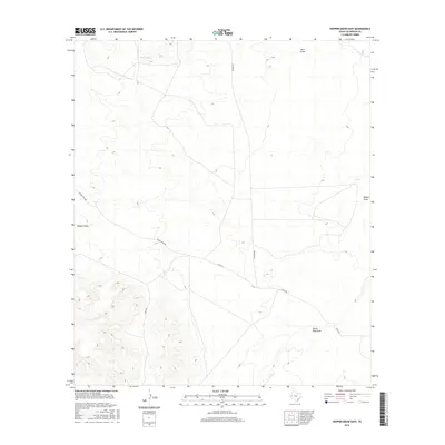
2016 Map of Hopper Draw East
USGS Topo · Published 2016About this map
North Tank provides a rare water reference point in this arid stretch of Culberson County, where the landscape is defined by its drainage patterns rather than permanent settlements. This 2016 survey illustrates a network of remote ranching and service roads, including the Elcor-Toyah Rd and Toyah Rd, which navigate the wide basins and shifting elevations of the Trans-Pecos. The topography is shaped by prominent dry watercourses like Hart Draw, Hopper Draw, and Herds Pass Draw, which channel seasonal runoff through the scrubland. These features reveal the fundamental geological and hydrological challenges for those managing land or tracing regional history in this sparsely populated portion of West Texas, where the intersection of Gresham Rd and Kent Rd marks the limited human footprint on the terrain.
Find a feature on this map
8 named features on this map. Tap any name to fly to it.
Don’t see what you’re looking for? This feature index may not catch every label — zoom into the map to look around manually.
Map Details
Editions of this 2016 Hopper Draw East Map
This is the sole edition of this map. No revisions or reprints were ever made.
Other maps of this area

1928 · Kent
USGS Topo · 1:125,000

1954 · Van Horn
USGS Topo · 1:250,000

1958 · Van Horn
USGS Topo · 1:250,000
1970 · Panther Canyon
USGS Topo · 1:24,000
1970 · San Martine
USGS Topo · 1:24,000
1970 · Iron Mountain
USGS Topo · 1:24,000

1973 · Dellahunt Draw West
USGS Topo · 1:24,000
1973 · Burnt Spring Hills SE
USGS Topo · 1:24,000
1973 · Dellahunt Draw East
USGS Topo · 1:24,000
1973 · Burnt Spring Hills
USGS Topo · 1:24,000