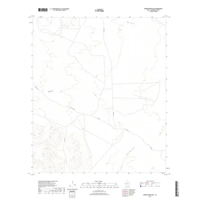
2019 Map of Hopper Draw East
USGS Topo · Published 2019About this map
Ephemeral drainage patterns and livestock infrastructure define this corner of the Trans-Pecos, where the arid landscape is etched by a series of seasonal watercourses. The prominent namesake Hopper Draw cuts through the central terrain, joined by Hart Draw to the north and the winding path of Herds Pass Draw in the southeast. These natural landmarks provided crucial orientation for early ranching operations, supported by localized water sources like North Tank.
Find a feature on this map
8 named features on this map. Tap any name to fly to it.
Don’t see what you’re looking for? This feature index may not catch every label — zoom into the map to look around manually.
Map Details
Editions of this 2019 Hopper Draw East Map
This is the sole edition of this map. No revisions or reprints were ever made.
Other maps of this area

1928 · Kent
USGS Topo · 1:125,000

1954 · Van Horn
USGS Topo · 1:250,000

1958 · Van Horn
USGS Topo · 1:250,000
1970 · Panther Canyon
USGS Topo · 1:24,000
1970 · San Martine
USGS Topo · 1:24,000
1970 · Iron Mountain
USGS Topo · 1:24,000

1973 · Dellahunt Draw West
USGS Topo · 1:24,000
1973 · Burnt Spring Hills SE
USGS Topo · 1:24,000
1973 · Dellahunt Draw East
USGS Topo · 1:24,000
1973 · Burnt Spring Hills
USGS Topo · 1:24,000