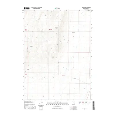
2015 Map of Hoppin Peaks
USGS Topo · Published 2015About this map
Hoppin Peaks and Salient Peak dominate this high-desert landscape in northern Nevada, where complex drainages and elevation changes define the topography. The Quinn River threads through the eastern portion of the quadrangle, serving as the primary hydrological feature alongside Skull Cr and Cherry Spring. The presence of these water sources amidst the arid terrain highlights the critical natural resources that have historically dictated movement and land use in this part of Humboldt County.
Find a feature on this map
14 named features on this map. Tap any name to fly to it.
Don’t see what you’re looking for? This feature index may not catch every label — zoom into the map to look around manually.
Map Details
Editions of this 2015 Hoppin Peaks Map
This is the sole edition of this map. No revisions or reprints were ever made.
Other maps of this area

1882 · Paradise
USGS Topo · 1:250,000

1893 · Paradise
USGS Topo · 1:250,000

1955 · McDermitt
USGS Topo · 1:250,000

1959 · McDermitt
USGS Topo · 1:250,000

1959 · Orovada
USGS Topo · 1:62,500

1959 · McDermitt
USGS Topo · 1:62,500

1959 · Hinkey Summit
USGS Topo · 1:62,500

1959 · Jordan Meadow
USGS Topo · 1:62,500

1985 · Quinn River Valley
USGS Topo · 1:100,000
1991 · Hoppin Peaks
USGS Topo · 1:24,000