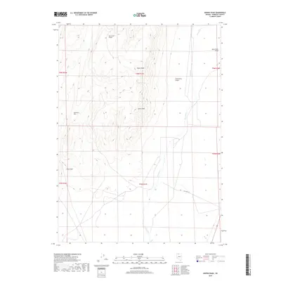
2018 Map of Hoppin Peaks
USGS Topo · Published 2018About this map
Hoppin Peaks and Salient Peak anchor this high-desert landscape in the northern reaches of the Great Basin. The Quinn River meanders through the eastern portion of the map, defining the Quinn River Valley and creating a stark contrast to the surrounding arid terrain of the Sentinel Hills. This 2018 survey illustrates a region largely shaped by its topography, where water sources like Cherry Spring and the drainage of Skull Cr are critical landmarks. Human activity is sparse, centered primarily on the transit corridor of Flat Creek Rd, which skirts the base of the mountains. The map provides a detailed view of the complex drainages of McConnell Canyon, Chokecherry Canyon, and Long Canyon, showing how these natural features dictate the movement and settlement patterns in this part of Humboldt County.
Find a feature on this map
17 named features on this map. Tap any name to fly to it.
Don’t see what you’re looking for? This feature index may not catch every label — zoom into the map to look around manually.
Map Details
Editions of this 2018 Hoppin Peaks Map
This is the sole edition of this map. No revisions or reprints were ever made.
Other maps of this area

1882 · Paradise
USGS Topo · 1:250,000

1893 · Paradise
USGS Topo · 1:250,000

1955 · McDermitt
USGS Topo · 1:250,000

1959 · McDermitt
USGS Topo · 1:250,000

1959 · Orovada
USGS Topo · 1:62,500

1959 · McDermitt
USGS Topo · 1:62,500

1959 · Hinkey Summit
USGS Topo · 1:62,500

1959 · Jordan Meadow
USGS Topo · 1:62,500

1985 · Quinn River Valley
USGS Topo · 1:100,000
1991 · Hoppin Peaks
USGS Topo · 1:24,000