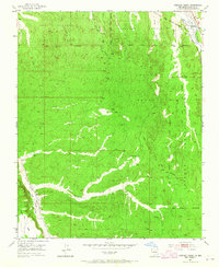
1953 Map of Horcado Ranch
USGS Topo · Published 1965About this map
San Ildefonso Pueblo Grant and the Pojoaque Pueblo Grant dominate this mid-century landscape north of Santa Fe, where historical land grant boundaries intersect complex drainage systems. The survey detail highlights the intricate network of watercourses including Arroyo Calabasa, Arroyo Ancho, and the Rio Tesuque, illustrating the importance of water management in this arid high-desert environment. Small settlements such as Horcado Ranch and Cuyamungue appear alongside evidence of human infrastructure and movement across the terrain. An interesting industrial relic, the Old Pipe Line Railroad Grade, runs through the western section near Caja Mesa, providing a specific point of interest for those tracking former rail alignments and utility corridors. Numerous jeep trails and paths weave through the Jacona Grant, reflecting the rural and traditional land use patterns of the early 1950s.
Find a feature on this map
23 named features on this map. Tap any name to fly to it.
Don’t see what you’re looking for? This feature index may not catch every label — zoom into the map to look around manually.
Map Details
Editions of this 1953 Horcado Ranch Map
5 editions found

Other maps of this area

1889 · Santa Fe
USGS Topo · 1:125,000

1892 · Santa Clara
USGS Topo · 1:125,000

1894 · Santa Fe
USGS Topo · 1:125,000

1951 · Agua Fria
USGS Topo · 1:24,000

1952 · Santa Fe
USGS Topo · 1:24,000

1952 · White Rock
USGS Topo · 1:24,000

1952 · Puye
USGS Topo · 1:24,000

1952 · Montoso Peak
USGS Topo · 1:24,000

1953 · Tesuque
USGS Topo · 1:24,000

1953 · Espanola
USGS Topo · 1:24,000