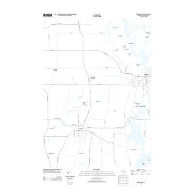
2013 Map of Horicon
USGS Topo · Published 2013About this map
Horicon and the surrounding marshlands of the Rock River define this 2013 landscape in Dodge County. The settlement patterns are anchored by the city of Juneau to the southwest and the rail-oriented hamlet of Minnesota Junction, where State Road 26 and Wi-33 intersect. The eastern portion of the map is characterized by a complex river system leading toward Sinissippi Lake, featuring numerous named landforms such as Diamond Island, Coleman Islands, and Stony Island. This modern survey illustrates the proximity of the Dodge County Airport to the agricultural crossroads of Rolling Prairie and Burnett Corners. Farther south, the terrain transitions into the waters of Sinissippi Lake near Steffen Point, reflecting a geography shaped by glacial drainage and permanent wetlands that have long dictated the placement of local roads and communities.
Find a feature on this map
78 named features on this map. Tap any name to fly to it.
Don’t see what you’re looking for? This feature index may not catch every label — zoom into the map to look around manually.
Map Details
Editions of this 2013 Horicon Map
This is the sole edition of this map. No revisions or reprints were ever made.
Other maps of this area

1955 · Beaver Dam
USGS Topo · 1:62,500

1955 · Waupun
USGS Topo · 1:62,500

1955 · Fox Lake
USGS Topo · 1:62,500

1955 · Horicon
USGS Topo · 1:62,500

1957 · Madison
USGS Topo · 1:250,000

1960 · Madison
USGS Topo · 1:250,000

1975 · Horicon NW
USGS Topo · 1:24,000

1975 · Beaver Dam NE
USGS Topo · 1:24,000
1975 · Horicon NE
USGS Topo · 1:24,000
1975 · Waupun SE
USGS Topo · 1:24,000