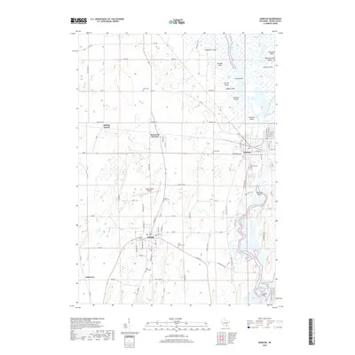
2018 Map of Horicon
USGS Topo · Published 2018About this map
The vast Horicon Marsh dominates the northern reaches of this Dodge County landscape, where the Rock River begins its southward journey toward Sinissippi Lake. The area's agricultural and civil history is evident in the cluster of small settlements and transportation hubs like Juneau and Horicon, as well as the intersection of Rolling Prairie and Minnesota Junction. This map provides a detailed view of the region's land use, from the managed wetlands and islands such as Fourmile Island and Stony Island to the vital aviation corridor of the Dodge County Airport. Numerous historic burial grounds, including Oak Hill Cem and Saint Mary's Cem, are meticulously plotted alongside the network of rural roads like Co RD E and Swan RD, providing essential landmarks for local historians and genealogists.
Find a feature on this map
86 named features on this map. Tap any name to fly to it.
Don’t see what you’re looking for? This feature index may not catch every label — zoom into the map to look around manually.
Map Details
Editions of this 2018 Horicon Map
This is the sole edition of this map. No revisions or reprints were ever made.
Other maps of this area

1955 · Beaver Dam
USGS Topo · 1:62,500

1955 · Waupun
USGS Topo · 1:62,500

1955 · Fox Lake
USGS Topo · 1:62,500

1955 · Horicon
USGS Topo · 1:62,500

1957 · Madison
USGS Topo · 1:250,000

1960 · Madison
USGS Topo · 1:250,000

1975 · Horicon NW
USGS Topo · 1:24,000

1975 · Beaver Dam NE
USGS Topo · 1:24,000
1975 · Horicon NE
USGS Topo · 1:24,000
1975 · Waupun SE
USGS Topo · 1:24,000