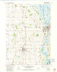
1980 Map of Horicon
USGS Topo · Published 1981About this map
The extensive wetlands of the Horicon Marsh State Public Hunting Grounds dominate the northeastern portion of this landscape, characterized by a complex of islands such as Clubhouse Island and Stony Island. This 1980s record illustrates a region defined by its water and transport networks, where the Rock River flows south toward Sinissippi Lake. The junction of the Chicago and North Western and Chicago Milwaukee St Paul and Pacific railroads at Minnesota Junction highlights the area's historical importance as a rail hub between Horicon and Juneau. Genealogists and local historians will find significant detail in the numerous burial sites across the townships, including Wrucke Cem, Stone Cem, and the County Home Cem near the County Health Facilities. The map also captures local land use from the Dodge County Airport to the recreational Rock River Hills Golf Course.
Find a feature on this map
53 named features on this map. Tap any name to fly to it.
Don’t see what you’re looking for? This feature index may not catch every label — zoom into the map to look around manually.
Map Details
Editions of this 1980 Horicon Map
This is the sole edition of this map. No revisions or reprints were ever made.
Other maps of this area

1955 · Beaver Dam
USGS Topo · 1:62,500

1955 · Waupun
USGS Topo · 1:62,500

1955 · Fox Lake
USGS Topo · 1:62,500

1955 · Horicon
USGS Topo · 1:62,500

1957 · Madison
USGS Topo · 1:250,000

1960 · Madison
USGS Topo · 1:250,000

1975 · Horicon NW
USGS Topo · 1:24,000

1975 · Beaver Dam NE
USGS Topo · 1:24,000
1975 · Horicon NE
USGS Topo · 1:24,000
1975 · Waupun SE
USGS Topo · 1:24,000