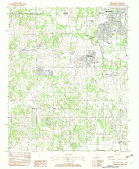
1982 Map of Horn Lake
USGS Topo · Published 1982About this map
Memphis and Southaven anchor the northern reaches of this 1980s landscape, marking the intersection of the Tennessee Mississippi state line and the Shelby Co. De Soto Co. border. The map captures an era of expanding suburbanization transitioning into the rural drainage basins of Chickasaw Bayou and Rocky Creek. Established communities like Horn Lake and Nesbit are shown alongside smaller crossroads and agricultural clusters such as Lynchburg, West Days, and Deans Corner. The presence of several Gravel Pits indicates the local extractive industry, while named water bodies like Lake Lipscomb and Cow Pen Creek define the natural topography south of the Chickasaw Base Line. This provisional survey provides a clear view of the residential developments, such as Twin Lakes, as they began to fill the spaces between the historic settlements of northwestern Mississippi.
Find a feature on this map
22 named features on this map. Tap any name to fly to it.
Don’t see what you’re looking for? This feature index may not catch every label — zoom into the map to look around manually.
Map Details
Editions of this 1982 Horn Lake Map
This is the sole edition of this map. No revisions or reprints were ever made.
Other maps of this area

1908 · Lake Cormorant
USGS Topo · 1:24,000

1912 · Lake Cormorant
USGS Topo · 1:31,680

1916 · Memphis
USGS Topo · 1:62,500

1925 · Memphis
USGS Topo · 1:48,000

1927 · Memphis
USGS Topo · 1:62,500

1932 · Horn Lake
USGS Topo · 1:48,000

1935 · Horn Lake
USGS Topo · 1:62,500

1939 · Memphis
USGS Topo · 1:62,500

1944 · Hernando
USGS Topo · 1:62,500

1948 · Helena
USGS Topo · 1:250,000