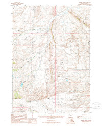
1987 Map of Horner Creek
USGS Topo · Published 1988About this map
The Meeteetse Rim anchors this high-elevation landscape, where the convergence of numerous drainages defines the topography south of the Greybull River. The 1980s terrain is marked by a legacy of resource extraction, from the Half Moon Oil Field in the north to a Coal Mine tucked along the eastern edge of Oregon Ridge. Energy infrastructure is prominent throughout, with multiple tanks and a north-south Trans Line cutting across the sagebrush-covered hills.
Find a feature on this map
23 named features on this map. Tap any name to fly to it.
Don’t see what you’re looking for? This feature index may not catch every label — zoom into the map to look around manually.
Map Details
Editions of this 1987 Horner Creek Map
This is the sole edition of this map. No revisions or reprints were ever made.
Other maps of this area

1911 · Meeteetse
USGS Topo · 1:62,500

1911 · Oregon Basin
USGS Topo · 1:62,500

1913 · Oregon Basin
USGS Topo · 1:62,500

1913 · Meeteetse
USGS Topo · 1:62,500

1955 · Cody
USGS Topo · 1:250,000

1957 · Devils Tooth
USGS Topo · 1:62,500

1957 · Sunshine Reservoir
USGS Topo · 1:62,500

1958 · Cody
USGS Topo · 1:250,000

1962 · Cody
USGS Topo · 1:250,000

1980 · Carter Mountain
USGS Topo · 1:100,000