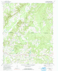
1971 Map of Hornsboro
USGS Topo · Published 1991About this map
Hornsboro and the outskirts of Pageland anchor this rural landscape along the border of North Carolina and South Carolina. Surveyed in the early 1970s, the terrain is defined by a dense network of watercourses, including Thompson Creek and Stone House Creek, which drain the low ridges and agricultural fields of Chesterfield and Anson counties. The map captures a moment when the regional economy was centered around local resources, evidenced by several Sandpits and a Quarry in the northern section near Little Brown Creek.
Find a feature on this map
40 named features on this map. Tap any name to fly to it.
Don’t see what you’re looking for? This feature index may not catch every label — zoom into the map to look around manually.
Map Details
Editions of this 1971 Hornsboro Map
2 editions found
Other maps of this area

1941 · Spartanburg
USGS Topo · 1:250,000

1953 · Spartanburg
USGS Topo · 1:250,000

1960 · Spartanburg
USGS Topo · 1:250,000

1963 · Spartanburg
USGS Topo · 1:250,000

1964 · Spartanburg
USGS Topo · 1:250,000

1968 · Ruby
USGS Topo · 1:24,000

1968 · Jefferson
USGS Topo · 1:24,000

1968 · Jefferson NE
USGS Topo · 1:24,000

1970 · Marshville
USGS Topo · 1:24,000
1970 · Wingate
USGS Topo · 1:24,000