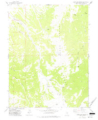
1973 Map of Horse Camp Springs
USGS Topo · Published 1977About this map
The Schell Creek Range dominates this mid-1970s topographical record of eastern Nevada, where high-elevation terrain is defined by a critical network of water sources. The namesake Horse Camp Springs and South Horse Camp Spring are central to the landscape, supporting the seasonal movements of livestock through the drainage of Horse Camp Wash. The naming of Basque Canyon provides a subtle nod to the region's cultural history, reflecting the legacy of Basque sheepherders who once moved their flocks through these canyons. Evidence of local land use appears in the northwest at a Borrow Pit, while a system of jeep trails connects remote points like Stevens Spring and Rock Spring. The geography is steeply incised by several washes, including John Henry Wash and Cattle Camp Wash, illustrating the harsh but necessary hydrology that sustained ranching and transit in White Pine County.
Find a feature on this map
20 named features on this map. Tap any name to fly to it.
Don’t see what you’re looking for? This feature index may not catch every label — zoom into the map to look around manually.
Map Details
Editions of this 1973 Horse Camp Springs Map
This is the sole edition of this map. No revisions or reprints were ever made.
Other maps of this area

1952 · Ely
USGS Topo · 1:125,000

1956 · Lund
USGS Topo · 1:250,000

1956 · Ely
USGS Topo · 1:250,000

1958 · Ely
USGS Topo · 1:62,500

1959 · Ely
USGS Topo · 1:250,000

1959 · Connors Pass
USGS Topo · 1:62,500

1960 · Lund
USGS Topo · 1:250,000

1963 · Ely
USGS Topo · 1:250,000
1973 · White Rock Creek
USGS Topo · 1:24,000

1973 · Cattle Camp Spring
USGS Topo · 1:24,000