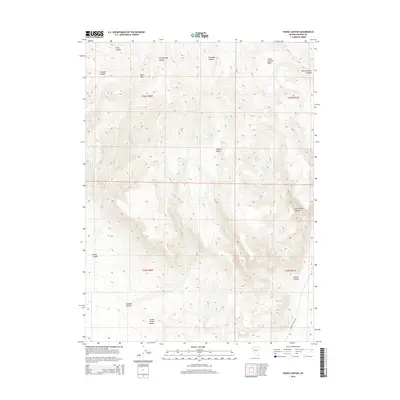
2014 Map of Horse Canyon
USGS Topo · Published 2014About this map
The vast, arid margins of the Smoke Creek Desert dominate the southern portion of this Washoe County landscape. The terrain is defined by a dense network of canyons and high basins, including Five Springs Canyon, Willow Basin, and Little Sawmill Basin, separated by prominent heights like Burnt Mtn. Water sources are the critical lifeblood of this environment, appearing as isolated springs scattered across the high ground, such as Horse Canyon Spring, Granite Spring, and Cottonwood Spring. Human movement through this remote territory is primarily facilitated by the Surprise Valley Rd, which skirts the edge of the desert floor. The distribution of these water points and the naming of features like Stockade Canyon suggest a history of livestock management and seasonal transit through the Great Basin.
Find a feature on this map
26 named features on this map. Tap any name to fly to it.
Don’t see what you’re looking for? This feature index may not catch every label — zoom into the map to look around manually.
Map Details
Editions of this 2014 Horse Canyon Map
This is the sole edition of this map. No revisions or reprints were ever made.
Other maps of this area

1886 · Granite Range
USGS Topo · 1:250,000

1894 · Granite Range
USGS Topo · 1:250,000

1955 · Lovelock
USGS Topo · 1:250,000

1959 · Lovelock
USGS Topo · 1:250,000

1980 · Salt Marsh
USGS Topo · 1:24,000
1980 · Buffalo Creek
USGS Topo · 1:24,000

1980 · Hog Spring
USGS Topo · 1:24,000

1980 · Wall Spring
USGS Topo · 1:24,000

1980 · Smith Canyon
USGS Topo · 1:24,000
1981 · Eddies Garden
USGS Topo · 1:24,000