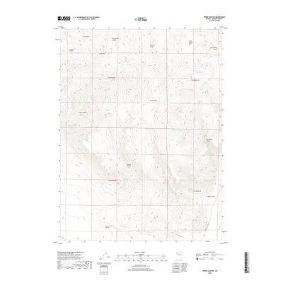
2018 Map of Horse Canyon
USGS Topo · Published 2018About this map
Smoke Creek Desert margins meet the uplifted terrain of northwestern Nevada in this detailed 2018 survey. The landscape is defined by its seasonal hydrology, where numerous named sources such as Parker Spring, Cottonwood Spring, and Horse Canyon Spring emerge from the slopes. These water points were historically vital for transit and livestock in the high desert environment.
Find a feature on this map
26 named features on this map. Tap any name to fly to it.
Don’t see what you’re looking for? This feature index may not catch every label — zoom into the map to look around manually.
Map Details
Editions of this 2018 Horse Canyon Map
This is the sole edition of this map. No revisions or reprints were ever made.
Other maps of this area

1886 · Granite Range
USGS Topo · 1:250,000

1894 · Granite Range
USGS Topo · 1:250,000

1955 · Lovelock
USGS Topo · 1:250,000

1959 · Lovelock
USGS Topo · 1:250,000

1980 · Salt Marsh
USGS Topo · 1:24,000
1980 · Buffalo Creek
USGS Topo · 1:24,000

1980 · Hog Spring
USGS Topo · 1:24,000

1980 · Wall Spring
USGS Topo · 1:24,000

1980 · Smith Canyon
USGS Topo · 1:24,000
1981 · Eddies Garden
USGS Topo · 1:24,000