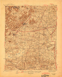
1938 Map of Horse Cave
USGS Topo · Published 1944About this map
Mammoth Onyx Cave and Wonderland Cave define this karst-dominated landscape in south-central Kentucky during the mid-1930s. The region is bisected by the Louisville and Nashville railroad and the Dixie Highway, which connect the prominent cave-country towns of Horse Cave and Cave City. This 1935 survey reveals a remarkably dense network of rural infrastructure, from the State Fish Hatchery on Beaver Creek to the Walton Academy.
Find a feature on this map
83 named features on this map. Tap any name to fly to it.
Don’t see what you’re looking for? This feature index may not catch every label — zoom into the map to look around manually.
Map Details
Editions of this 1938 Horse Cave Map
2 editions found
Other maps of this area

1922 · Mammoth Cave
USGS Topo · 1:62,500

1923 · Mammoth Cave
USGS Topo · 1:62,500

1925 · Cub Run
USGS Topo · 1:62,500

1926 · Scottsville
USGS Topo · 1:62,500

1934 · Munfordville
USGS Topo · 1:48,000

1935 · Horse Cave
USGS Topo · 1:48,000

1937 · Munfordville
USGS Topo · 1:62,500

1938 · Horse Cave
USGS Topo · 1:62,500

1953 · Sulphur Well
USGS Topo · 1:24,000

1953 · Hudgins
USGS Topo · 1:24,000