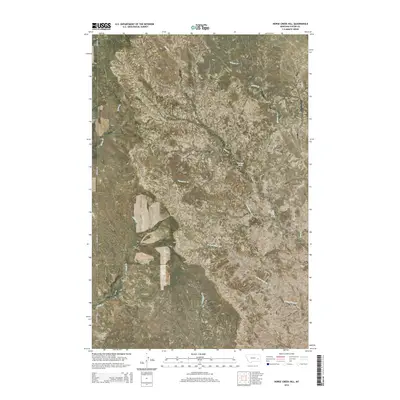
2014 Map of Horse Creek Hill
USGS Topo · Published 2014About this map
Horse Creek Hill rises as a prominent landmark in this Custer County landscape, where the drainage patterns of several intermittent streams define the terrain. The map details a network of waterways including Horse Cr and Muster Cr in the north, giving way to Thompson Cr and the W Fork Sand Cr further south. This area of Montana remains sparsely developed, characterized primarily by the Public Land Survey System grid and ranch access via Deadman Rd. A singular water source, Clevenger Spring, is noted near the center of the sheet, highlighting the importance of reliable water points in this arid region. The topography is dominated by the ridges and coulees that feed into Sand Cr, reflecting the natural erosion patterns typical of the Montana plains.
Find a feature on this map
13 named features on this map. Tap any name to fly to it.
Don’t see what you’re looking for? This feature index may not catch every label — zoom into the map to look around manually.
Map Details
Editions of this 2014 Horse Creek Hill Map
This is the sole edition of this map. No revisions or reprints were ever made.
Other maps of this area

1953 · Miles City
USGS Topo · 1:250,000

1954 · Forsyth
USGS Topo · 1:250,000

1957 · Miles City
USGS Topo · 1:250,000

1957 · Forsyth
USGS Topo · 1:250,000

1958 · Miles City
USGS Topo · 1:250,000

1958 · Forsyth
USGS Topo · 1:250,000

1965 · Twin Buttes School
USGS Topo · 1:24,000

1965 · Morehouse Creek
USGS Topo · 1:24,000
1965 · Crow Rock SE
USGS Topo · 1:24,000

1969 · Horse Creek Hill
USGS Topo · 1:24,000